
Well, today's trip to Kew was extremely successful!
All images below are reproduced with permission.
I wasn't anticipating finding much, but when collecting the first lot of records this is what I was presented with:

When unfurled this revealed a wealth of plans and long sections of the line including details of bridges, viaducts, and tunnels.

You'll have to excuse the weights on the end of the sheets in some shots, it was a constant battle to stop the sheets curling back up again! It all looked like it had'nt seen the light of day for some considerable time.
Here's an overview map of the whole system drawn onto an OS map sheet. Railway 1 runs from Isle Ornsay to Uig (52 miles in total), whilst Railway 2 branches off Railway 1 approximately 3 miles North of Portree and runs a further 24 miles to Dunvegan.

The trackplan I drew up for Armadale a while ago conveniently fits nicely into the area where Isle Ornsay station was proposed.
The sheet that shows the section of line I'm going to model is shown below:

More specifically the area immediately around Isle Ornsay station and pier:


As can be seen from the long section, the line was planned to pass through a headland in an 80 yard long tunnel - an ideal break for a fiddle yard! :)
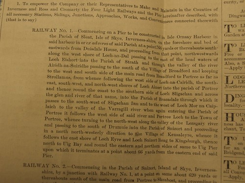
Below is a general description of Railway 1 for it's entire length.
Notice to build the line under an order from the 1896 Light Railways Act in the form of an advert placed in the Northern Weekly on Thursday the 21st April 1898.

The line was proposed by a group of people from the London area. The directors are listed as being a Mr. Andrew M. Barr of Eltham, Harold E. Lewin also of Eltham, Charles Kemble (unreadable location), A. Hambury Tracey of Queensgate, W.M. Godward of Enfield, J.W. Hume Williams of Gloster Place, and T. Beaumont Hesseltine of Bond Street.
Some of the above were part of a well known railway manufacturer who's head office address matches that of the Hebridean Light Railway Co.

Dick Kerr feature on a lot of the paperwork and are listed as the promoter and official contractor for the line.
I've found several references to this proposal in different books, some mentioned the involvement of the North British Railway, the records don't show this. In one document it is stated that the line wasn't built due to lack of funds and the plan was abandoned. The company correspondence does make reference to them not wanting to immediately dissolve the company as they were keen to try and restart it in the future.
To make the model I have made one assumption:
When the costs for the line came in at more than expected (£598,977 9s 9d) the HLR approached the NBR to see if they would be interested in a joint project. The NBR agreed and part funded the line as well as agreeing to provide stock, and operate it. The provision of a government grant which the NBR aided the line in obtaining, was a great help towards some of the construction fees.
This would have meant that the line was more likely to get built, and to a reasonable standard with some interesting potential for stock.
The Highland Railway were approached to build a line on Skye and refused to do so on two occasions, so the NBR was the logical choice for this, especially as they were working on the Mallaig extension to the West Highland Line at the time this scheme was being proposed. Ferries could then have been run form Isle Ornsay to Mallaig to provide a connecting service.
The layout will be approximately a 9'x9' L shape, i'll be firming up the trackplan soon after i've made alterations to it to reflect the change in location. Things that will change are mainly the location, type and orientation of buildings as well as a minor re-site of the turntable and the addition of a tunnel mouth as the exit to the fiddle yard.
I wil be using some of the details from the National Archives (plus a little imagination) to write a history to accompany the layout.
The plans also showed lines proposed across the conjoined islands of Lewis and Harris, namely Railways 3 and 4. I will post some more details of this at some point if people are interested.
I've not modelled a real life location before, but the opportunity to do so is something that i'm looking forward to, although the proposed line will allow me to model the area immediately around the station as it could have developed had the line been built.
3 comments:
Fascinating! You must have felt as happy as a pig in the proverbial going through all these papers! So your layout is now moving to Isle Ornsay instead of Armadale, right? It'll be fascinating reading up the history of IO for background detail. Have a look at the RCAHMS website - http://canmore.rcahms.gov.uk/
I used to go sailing to IO quite a lot and it's very shallow so I wonder if some dredging might have been necessary to allow steamers up to the pier?
I'll also be interested to hear about the proposals in Lewis and Harris because research I've been doing recently suggests that the Pentland Road was NOT the trackbed of a LR which was never built as is popularly supposed.
All the best, Neil
I was indeed, Neil. I'm very pleased to have tracked down the material and that it was so comprehensive and in such reasonable condition!
I'll take a read of that website, it'll be good to incorporate some local history into the layout.
The setting for the station is actually about 0.5 miles North of IO near Duisdale house. The water seems a lot deeper there, so I'm assuming that was the main reason for proposing to build the terminus there. That and the fact that I think the line would have required a 500m long tunnel to progress any further south.
The layout will indeed by IO, fortunately the trackplan I produced for Armadale will fit easily in the plan for IO.
To be honest I didn't get masses of details from the Lewis/Harris proposals, I was more excited about Skye, but i'll be posting what I have on it at some point. If you like I could send you the images if you wanted to do your post on the Pentland Road still?
Cheers,
Tom.
Hi Tom,
Just for accuracy's sake....
You mention one of the directors as being a "T Beaumont Hesseltine of Bond Street. It should read "F(for Frederick) Beaumont Hesseltine".
Our house in Islington, North London was a girls' boarding school 1887-95 that also offered preparatory teaching of young boys. Hence Mr Hesseltine's son William being listed on the 1891 Census for our house. I am researching the lives of the known staff and pupils and their families. F. B. Hesseltine lived in Bond Street for several years and was a stockbroker and company director.
Paul Klein
Post a Comment